Sells, Arizona
Sells, Arizona
O'odham: Komkcʼeḍ ʼe-Wa:ʼosidk | |
|---|---|
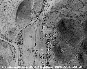
 Sells Indian School, 1940s | |
 Location in Pima County and the state of Arizona | |
| Coordinates: 31°54′46″N 111°52′31″W / 31.91278°N 111.87528°W | |
| Country | |
| State | |
| County | Pima |
| Tribe | |
| Area | |
| • Total | 9.24 sq mi (23.94 km2) |
| • Land | 9.23 sq mi (23.92 km2) |
| • Water | 0.01 sq mi (0.02 km2) |
| Elevation | 2,392 ft (729 m) |
| Population (2020) | |
| • Total | 2,121 |
| • Density | 229.69/sq mi (88.68/km2) |
| Time zone | UTC-7 (MST (no DST)) |
| ZIP code | 85634 |
| Area code | 520 |
| FIPS code | 04-65490 |
| GNIS feature ID | 11073 |
Sells (O'odham: Komkcʼeḍ ʼe-Wa:ʼosidk) is an unincorporated community and census-designated place (CDP) in Pima County, Arizona, United States. The population was 2,799 at the 2000 census. It is the capital of the Tohono O'odham Nation and the home of several of their tribal businesses, such as Tohono O'Odham Ki:Ki Association. Originally named Indian Oasis, by cattle-ranchers/businessmen brothers, Joseph and Louis Ménager in 1912. The Ménager brothers also built and ran the Indian Oasis Mercantile Store. The settlement took its present English name in 1918 to honor Indian Commissioner Cato Sells.[2] The O'odham name means "Tortoise Got Wedged".
Sells is near the Kitt Peak National Observatory.
Geography
[edit]Sells is located at 31°54′54″N 111°52′32″W / 31.91500°N 111.87556°W (31.914994, -111.875669).[3]
According to the United States Census Bureau, the CDP has a total area of 9.4 square miles (24 km2), of which 9.4 square miles (24 km2) is land and 0.11% is water.
Demographics
[edit]| Census | Pop. | Note | %± |
|---|---|---|---|
| 2020 | 2,121 | — | |
| U.S. Decennial Census[4] | |||
As of the census[5] of 2000, there were 2,799 people, 690 households, and 565 families residing in the CDP. The population density was 298.9 inhabitants per square mile (115.4/km2). There were 810 housing units at an average density of 86.5 per square mile (33.4/km2). The racial makeup of the CDP was 96% Native American, 3% White, <1% Black or African American, <1% Asian, <1% from other races, and <1% from two or more races. 3% of the population were Hispanic or Latino of any race.
There were 690 households, out of which 42.3% had children under the age of 18 living with them, 26% were married couples living together, 44% had a female householder with no husband present, and 18% were non-families. 14% of all households were made up of individuals, and 2% had someone living alone who was 65 years of age or older. The average household size was 4.0 and the average family size was 4.3.
In the CDP, the population was spread out, with 42% under the age of 18, 11% from 18 to 24, 27% from 25 to 44, 16% from 45 to 64, and 5% who were 65 years of age or older. The median age was 23 years. For every 100 females, there were 93.3 males. For every 100 females age 18 and over, there were 82.2 males.
The median income for a household in the CDP was $20,610, and the median income for a family was $20,294. Males had a median income of $25,278 versus $22,396 for females. The per capita income for the CDP was $6,283. About 42% of families and 46% of the population were below the poverty line, including 51% of those under age 18 and 41% of those age 65 or over.
Education
[edit]Baboquivari Unified School District operates area public schools, while Tohono O'odham High School is a Bureau of Indian Affairs high school.
References
[edit]- ^ "2020 U.S. Gazetteer Files". United States Census Bureau. Retrieved October 29, 2021.
- ^ Kitt Peak
- ^ "US Gazetteer files: 2010, 2000, and 1990". United States Census Bureau. February 12, 2011. Retrieved April 23, 2011.
- ^ "Census of Population and Housing". Census.gov. Retrieved June 4, 2016.
- ^ "U.S. Census website". United States Census Bureau. Retrieved January 31, 2008.


