Mid Murray Council
| Mid Murray Council South Australia | |||||||||||||||
|---|---|---|---|---|---|---|---|---|---|---|---|---|---|---|---|
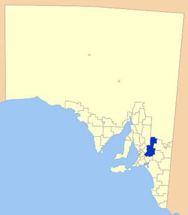
 Location of the Mid Murray Council in SA | |||||||||||||||
| Coordinates | 34°36′46″S 139°33′09″E / 34.6129°S 139.5525°E | ||||||||||||||
| Established | 1997 | ||||||||||||||
| Area | 7,957 km2 (3,072.2 sq mi) | ||||||||||||||
| Mayor | Simone Bailey[1] | ||||||||||||||
| Council seat | Mannum | ||||||||||||||
| Region | Murray and Mallee[2] | ||||||||||||||
| State electorate(s) | Chaffey, Schubert, Hammond, Stuart | ||||||||||||||
| Federal division(s) | Barker | ||||||||||||||
 | |||||||||||||||
| Website | Mid Murray Council | ||||||||||||||
| |||||||||||||||
The Mid Murray Council is a local government area in South Australia in the Murray and Mallee region of South Australia.[3] The council spans the area from the Riverland through the Murraylands to the eastern slopes of the Mount Lofty Ranges. It includes 220 km of the Murray River. The council seat is at Mannum; it also maintains secondary offices at Cambrai and Morgan.[4]
It was formed on 1 July 1997 from the amalgamation of the District Council of Mannum, the District Council of Morgan, the District Council of Ridley-Truro and part of the District Council of Mount Pleasant.[5][6][7]
Geography
[edit]The council's main centres include the river towns of Mannum, Swan Reach, Blanchetown and Morgan and the hills towns of Truro, Palmer and Tungkillo. It also includes a large number of rural localities, including Angas Valley, Annadale, Apamurra, Beatty, Beaumonts, Big Bend, Bolto, Brenda Park, Cadell, Cadell Lagoon, Cambrai, Caurnamont, Claypans, Cowirra, Dutton East, Eba, Fisher, Five Miles, Forster, Frahns, Frayville, Julanka Holdings, Keyneton, Lake Carlet, Langs Landing, Lindley, Maude, Marks Landing, McBean Pound, Morphetts Flat, Mount Mary, Milendella, Nildottie, North West Bend, Old Teal Flat, Pellaring Flat, Pompoota, Ponde, Port Mannum, Punthari, Punyelroo, Purnong, Rocky Point, Sanderston, Sandleton, Sedan, Stuart, Sunnydale, Teal Flat, Towitta, Walker Flat, Wombats Rest, Wongulla, Younghusband, Younghusband Holdings and Zadows Landing, and parts of Birdwood, Bower, Bowhill, Brownlow, Burdett, Caloote, Dutton, Eden Valley, Frankton, Mount Pleasant, Mount Torrens, Murbko, Rockleigh, Springton, Steinfeld, Taylorville, Tepko and Wall Flat.[8]
Councillors
[edit]| Ward | Councillor | Notes | |
|---|---|---|---|
| Mayor[1] | Simone Bailey | ||
| Eyre Ward[1] | John Forrester | Deputy Mayor | |
| Jen Davis | |||
| Murray Ward[1] | Geoff Barber | ||
| Roslyn Schultz | |||
| Shearer Ward[1] | Kelly Gladigau | ||
| Kirsty MacGregor | |||
| Mandy Toczek McPeake | |||
| Victoria Hammond | |||
Mid Murray Council has a directly-elected mayor.[9]
References
[edit]- ^ a b c d e "Elected Members". Mid Murray Council. Retrieved 31 March 2016.
- ^ "Murray and Mallee SA Government region" (PDF). The Government of South Australia. Retrieved 10 October 2014.
- ^ "Location SA Map Viewer". Government of South Australia. Retrieved 16 February 2016.
- ^ "Contact Us". Mid Murray Council. Retrieved 31 March 2016.
- ^ "Council Information". Mid-Murray Council. Retrieved 31 March 2016.
- ^ "Thursday, 13 February, 1997" (PDF). The Government Gazette of South Australia. Government of South Australia. Retrieved 2 December 2016.
- ^ "Thursday, 27 March 1997" (PDF). The Government Gazette of South Australia. Government of South Australia. Retrieved 2 December 2016.
- ^ "Location SA Map Viewer". Government of South Australia. Retrieved 31 March 2016.
- ^ "Election Results 2014" (PDF). Local Government Association of South Australia. Archived from the original (PDF) on 30 June 2007. Retrieved 14 February 2016.
